The Hoshen is a modern "sand table" that simulate terrain and animate moving forces in a dynamic way, along with a graphical representation of relevant data, as required.
It is located in 'war rooms' throughout the country, and serves senior officials with:
Prepare the outline for different operations in advance. Manage by real-time monitoring during the operation. Debriefing the events after the activity.
The “Hoshen” is designed to work ideally for two to six standing users, at a time. Each one of them can operate the utility.
Dynamic Physical Terrain Simulator
HOSHEN

 HOSHENA close-up on the Leaning Ring & Glass Panel. |  HOSHENCooling System (Frog View) |  Upper body - ProjectorJust above the center of the table, the upper system is installed and includes inside it - projectors and motion sensors, through which the infographics are being Screening, Synchronized to changes on the map. |
|---|---|---|
 HOSHEN (Main + Upper body)There is a distinction in the cartographic analysis, in such a way that the relief (surface and buildings) are illustrated physically in 3D, while the land cover and any other Infographic data ( ,roads, UAV, moving forces, ..) are projected on top of the relief. |  Projected Touch Screen -Upper body, projects the info and the relevant menu desired, on the dark glass screen, while simultaneously interprets the user interactions and reacts accordingly. |  HOSHENPhysical Model | Photo credit: Oded Antman |
 HOSHENMain body (top view) |  HOSHEN | UIOne of the interaction tools is "Hands gestures". The upper body interprets different gestures into Commands. |  HOSHEN | integrated FeatursConstruction plans, moving forces, cell phone tracking are only some of many Features that are installed in the Hoshen |
 HOSHEN | PixelsIn order to maximize the coverage area, and reach maximum accuracy, the pixels that appear in the three-dimensional map, are hexagons |
Scenario & Concept
Concept
In today’s digital world, space analysis tools have evolved considerably. Programs such as Google Earth and other three-dimensional maps are widely used.
“Hoshen” gives users a dynamic experience of traffic analysis and field orientation.
“Hoshen” magically combines physical three-dimensional simulation, a storehouse of many layers of information, and an intuitive user interface. The need for this type of product I noticed during my military service. I witnessed the importance of surface analysis in decision-making, mission success, and most importantly, in protecting human life.
Basis of the project:
The given situation is that the defense force regularly needs reliable geographic information systems, which allow them to analyze and learn the relevant fields and territories. On the basis of the stock GIS, maps, computer simulations and sometimes three-dimensional models are produced. Besides the large amount of time and money that is invested in their production, in many cases the same models and maps quickly become irrelevant and cause the same long and expensive process to take place over and over again.
After long, in-depth analysis, I arrived at several conclusions, which have led to a new product and a matching scenario, which together will exalt the system and the operational capacity of the various security agencies.
Scenario
As part of the Intelligence Corps, there is a unit whose task is matching the relevant intelligence information, and adapting it into one central GIS database in digital form. This information is represented by what is called the “Hoshen.”
The “Hoshen” is a means to simulate and animate terrain and moving forces in a dynamic way, along with a graphical representation of relevant data, as required. It is located in war rooms throughout the country, and serves senior officials to: Prepare the outline for different operations, management and real-time monitoring of what is happening, and helps in debriefing the events after the activity. In fact, this is a kind of a dynamic "sand table". The “Hoshen” is designed to work ideally for two to six standing users, at a time. Each one of them can operate the utility.
The underlying idea behind the “Hoshen” is a desire to make it possible to have better and faster data systems, together with the reduction of irrelevant data. Basic assumption, based on scientific studies, Claims that the human brain is able to remember, analyze and learn - a tangible object (three-dimensional), quicker than a photograph or drawing of that object. Furthermore, with an intuitive and simple user interface, users can concentrate more on the content of the task itself.
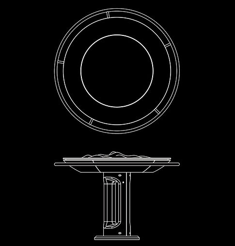
The stand consists of two main bodies: Lower Body – some kind of a table, and Upper Body – which contains the projector, camera and, and the 'Prime Sense' sensors ("Kinect").
In the heart of the lower body is the computer that holds and connects all the data. "The Field" which is located on top of the lower body, makes a simulation of a three-dimensional surface. Around "The Field" there is a 360-degree 'touch screen' in the form of a ring, which displays relevant information for the various users around the table, and it is also one element of the command and control system. The second and primary element of control in the “Hoshen” is based off hands movements (gestures). The Upper Body, which recognizes those movements, converts them to commands that were incorporated into the system. For example: quick navigation, changing focus, pointing to a point of interest, etc. Furthermore, the upper body projects graphic information on the "field" such as: the movement of forces, linear topography, aerial photograph, etc. There is a third element of control system in the operation, which is "Voice Activation".
Additional features embedded in the system:
- Compass embedded in the system with visual indication of light for the benefit of the orientation of those around
- Entering data in a simple and convenient manner
- Marking points of interest, territories and forces using only a finger
- Quick information sharing between different users
- Creating and running various simulations with the utility for study and practice
- Two-way communication with the forces in the field
- Real-time event recording for debriefing and analysis
- Move backwards on the timeline for understanding demographic and architectural changes
- UAV works closely with the system and data flows on demand, on an ongoing basis
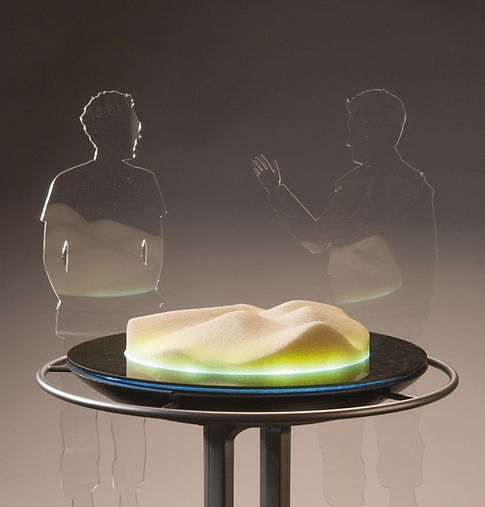
Physical Model | Photo credit: Oded Antman
Technique and materials:
Main materials: glass, stainless steel, plastic injection steel.
Hardware: a PC, micro-piezo motors, touch screen, projector, camera, Prime Sense sensors ('Kinect').
Software: GIS, image-processing software.
Dimensions: 140cm X 140cm X 120.